


A Brief Overview
Date: February 5, 2025
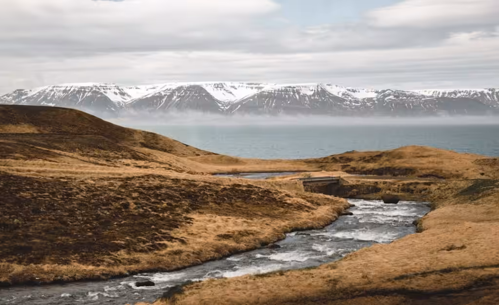
The year 2024 stood out for a number of reasons, most notably its uncharacteristically cold temperatures, which lingered throughout the nation. The average national temperature fell 0.8 degrees below the 1991–2020 mean, marking the coldest year since 1998. The northern regions faced the starkest chill, while milder conditions prevailed along the southern coast.
A wet summer enveloped the entire country, although every other season saw relatively dry conditions. Specifically, the eastern, southern, and southwestern regions experienced drier than usual weather, while the North and West received substantial rainfall during the warmer months. Throughout June to August, unusually low sea level pressures contributed to a series of low-pressure systems and unfavorable weather. Notably, aside from summer, weather patterns were relatively calm, with both annual mean sea level pressure and wind speed aligning closely with historical averages.
The winter of 2023-2024 was generally favorable, featuring mild conditions and a notable lack of stormy days; however, temperatures remained significantly below the norm across the board.
Spring showcased near-average temperatures, though a particularly cold April—especially in Northeast Iceland—witnessed lingering rain and snow. In contrast, May arrived with warmer temperatures, particularly in the northeast, while the southwest experienced a wetter climate.
As for the summer months (June through September), it was marked by unusual cold. All summer months, except for July, reported national average temperatures that were below normal; the conditions in the northeast warmed slightly during July. In Reykjavík, August saw its lowest average sea level pressure ever recorded, dating back to 1820, while a prolonged cold spell at summer’s onset brought an alarming amount of snow to the north.
Heavy rainfall during July and August resulted in significant flooding across rivers and streams, accompanied by landslides in areas hardest hit by the relentless downpours. However, September managed to bring respite, presenting a drier and sunnier disposition, albeit still chilly.
October ushered in colder, calmer, and drier weather overall. November, however, presented a tale of two halves: the first was uncommonly warm, becoming the warmest opening fortnight in recorded history for multiple weather stations. Regions experienced strong southerly winds that brought wet conditions to the south and west while the north and east basked in warmth and dryness. The month’s peak temperature reached an astonishing 23.8°C at Kvísker, the highest ever recorded for November in Iceland’s history. However, temperatures plummeted around mid-November, falling below average for the month’s latter half, resulting in an overall autumn temperature that was below normal.
By December, the weather turned relatively cold, with the northern and eastern regions remaining dry, while the west faced significant wet conditions.
Temperature Trends
In Reykjavík, the year 2024 recorded an average temperature of 4.3°C—0.9°C lower than the 1991–2020 average and 1.1°C below the last decade’s mean. Similar trends emerged in Stykkishólmur (3.7°C), Akureyri (3.3°C), and Egilsstaðir (3.2°C), all experiencing below-average temperatures relative to both longer-term and recent norms.
The coldest year since 1998 unfolded nationwide, with the average temperature dropping 0.8°C below the 1991–2020 mean. The starkest differences were felt inland in the north, while the southern coast remained relatively warmer. Notably, Flatey on Skjálfandi, Austurdalsháls, and Svartárkot recorded the largest negative anomalies—up to 1.4°C—compared to the last ten years.
The utmost high recorded temperature for the year was 27.5°C at Egilsstaðir Airport on July 14, while the chilling low of -28.2°C struck Svartárkot on December 31. Reykjavík’s year-end temperatures reflect a worrisome trend; the highest maximum was a bald 17.4°C, the coldest July high since 2001. Akureyri faced a summer peak of 23.8°C on June 30, with a winter low of -18.7°C on January 18.
Overall, 2024 proved remarkably cold when evaluated against century-long temperature trends. Nationwide, this year fell as the 77th to 78th warmest out of 151 years of recorded data, highlighting its distinction in more recent climate history.
Precipitation Patterns
Annual precipitation levels mirrored the temperature trends, largely falling below average in East, South, and Southwest Iceland, yet surpassing it in many areas of the North and West. While rainfall was abundant during the summer months, the other seasons drew in a notable lack of moisture.
Specific data showcases the annual precipitation levels at various weather stations. Reykjavík noted 827.7 mm, translating to about 95% of the average from 1991 to 2020—this total represents a drop to 88% against the last decade’s averages. Akureyri received slightly more, 585.2 mm, a small increase over the same period, though only 91% of the prior ten years’ figures.
Overall, September and October evoked drier conditions, while a dramatic summer rainstorm in mid-July led to historical records of flooding, notably in Grundarfjörður where 235.2 mm of rain fell in one day—marking it as the highest 24-hour precipitation recorded there.
The following months played host to more fluctuations; November split into two distinct weather states, with the initial half being notably wet and the latter half turning dry, particularly in northern regions.
Snow Coverage
Snow cover also painted a diverse picture across the country. Reykjavík experienced an average of 48 days with fully snow-covered ground, falling slightly short of the 1991–2020 norm. Conversely, Stykkishólmur witnessed an uptick, marking 67 snow-covered days—21 more than the average.
In Akureyri, snow cover thrived, clocking in at 122 days, a 27-day boost from normal. Notably, early June witnessed an extraordinary snowfall in North Iceland, challenging standard expectations and burdening local agricultural efforts.
Bright Sunshine
In the realm of solar exposure, Reykjavík logged 1,459.3 hours of bright sunshine—91 hours over the long-term average, while Akureyri recorded a total of 1,192.1 hours, exceeding the average by 141 hours. The sunshine hours dipped seriously in the gloamiest months, particularly May and July, yet remained robust in the early and late parts of the year.
Sea Level Pressure and Wind
Throughout the year, sea level pressure around Reykjavík matched the historical norm at 1005.1 hPa. Yet, 2024 also noted extremes, with the highest recorded pressure reaching 1041.7 hPa at Fagurhólsmýri on January 10, while the lowest plummeted to 950.0 hPa on October 18.
Wind patterns throughout the year were rather stable, remaining close to the 1991–2020 average. A notable prevalence of north-westerly and northerly winds emerged, while the southeast winds were surprisingly sparse.
In summary, 2024 brought forth an array of climatic extremes, painting a complex picture of Iceland’s ever-changing weather landscape. From cold temperatures to surprising rainfall, the year highlighted the dynamic and sometimes unpredictable elements of nature in this northern realm.


