


An eruption commenced north of Grindavík on April 1 at 9:44 AM. The fissure remains active, visibly lengthening, and there is a possibility it could extend further southward.
Dike Intrusion on April 1: The Largest Since November 2023
Updated April 8, at 16:15 UTC
- Microseismic activity persists near the dike but is gradually decreasing.
- Evidence of ongoing uplift beneath Svartsengi remains strong.
- The current uplift rate exceeds that experienced after previous eruptions.
- It is premature to determine the future rates of magma accumulation.
- Approximately 30 million cubic meters of magma escaped the chamber on April 1, marking the largest intrusion since November 10, 2023.
- The hazard assessment has been updated and is in effect until April 15, given stable conditions.
- With magma continuing to gather beneath Svartsengi, the likelihood of further intrusions or eruptions remains high.
Current data points to significant ongoing uplift beneath Svartsengi, rising at a rate that outpaces what was recorded after earlier eruptions. That is likely tied to the sheer volume of magma involved — roughly 30 million cubic meters — discharged during the April 1 event.
That said, it is too early to say how accumulation rates will develop from here. Historical patterns suggest they tend to slow as the gap between eruptions grows longer, and it will probably take at least a week before any clear shift becomes apparent.
All signs still point to a steady inflow of magma into the Svartsengi system, which means volcanic activity along the Sundhnúkur crater row is far from finished. The Icelandic Meteorological Office is watching developments closely and working through possible scenarios based on the latest data.
The data illustrates displacement at GPS station SENG in Svartsengi from November 11, 2023, including movements in the north, east, and vertical directions (top, middle, bottom). The latest measurement (April 7) is indicated by a green dot. Red lines denote the last eight eruptions (December 18, 2023; January 14; February 8; March 16; May 29; August 22; November 20, 2024; and April 1, 2025). Blue lines mark prior magma intrusions that did not result in eruptions (November 10, 2023, and March 2, 2024).
Dike Intrusion: The Largest Since November 2023
Modelling estimates put the volume of magma that flowed from the chamber beneath Svartsengi into a newly formed dike on April 1 at around 30 million cubic meters — the most significant intrusion recorded since November 10, 2023.
Microseismic activity is still being detected along the northern segment of the dike. Triggered earthquakes are also showing up near Reykjanestá and west of Kleifarvatn. Deformation in the northern part of the dike has eased somewhat, but GPS stations and satellite imagery both confirm that movement near the dike itself continues.
Updated Hazard Assessment
The hazard assessment has been revised and is valid until April 15, barring any major changes.
Several zones have shifted since the previous assessment:
- Zone 3 (Sundhnúkur crater row) has been downgraded from “high” (red) to “considerable” (orange).
- Zones 4 (Grindavík), along with Zones 5, 6, and 7, have shifted from “considerable” (orange) to “moderate” (yellow).
- Zone 1 remains classified as “moderate” (yellow).
Despite these changes, a real risk of ground subsidence into established faults remains.
Updated April 4, at 14:55 UTC
- There are signs that uplift has resumed in Svartsengi.
- Seismic activity near the dike has shown a decrease.
- Deformations continue to be detected at GPS stations around the northern dike.
- Uncertainty persists regarding developments in the coming days, and magma movements within the dike remain a possibility.
- Triggered quakes at Trölladyngja last night, including one measuring 3.9 in magnitude, were recorded.
- The hazard assessment has been updated and remains valid until April 8 unless conditions shift.
Recent GPS measurements suggest uplift may have resumed in Svartsengi, most likely driven by continued magma accumulation below the surface — though some of that uplift can also be traced to the dike formation on April 1. Deformation data keeps confirming movement at GPS stations in areas like Vogar and near Keilir. Satellite images captured between April 2 and 3 show displacement as well.
Decreasing Seismicity, Yet Deformation and Microseismic Activity Persist
Seismic activity over the northern part of the dike is gradually winding down, though small earthquakes keep occurring. Recent monitoring has logged around 20 to 30 earthquakes per hour, most below magnitude 1.0 — a far cry from peak rates that had exceeded 100 earthquakes per hour. These earthquakes are spread from Stóra-Skógfell in the south to just north of Keilir, at depths mostly between 4 to 6 km.
Most of the magma that left Svartsengi has settled into the dike formed on April 1, reaching depths of roughly 1.5 km in places. Deformation and microseismic activity remain notably elevated even as the trend points downward. The situation is still uncertain, and the possibility of further magma movement within the dike cannot be set aside.
The attached map illustrates all reviewed earthquakes on the Reykjanes Peninsula over the past 24 hours. It also highlights preliminary estimates of the dike’s location, extending from Grindavík to an area roughly three kilometers northwest of Keilir. The blue bars depict the hourly number of earthquakes—both reviewed and unreviewed—since the morning of April 1, showing a decline in total seismic events over the past day. The earthquake magnitudes have continued to diminish, with darker circles indicating reviewed events.
Swarm Near Trölladyngja Likely Triggered by Stress Changes
A notable earthquake swarm kicked off near Trölladyngja at 5:30 PM on April 3. The largest quake, measuring 3.9 in magnitude, was recorded around 11 PM. People in the surrounding populated areas felt the tremors, though activity began to taper off after midnight. Scientists believe these earthquakes were triggered by stress changes following the dike intrusion on April 1, and similar events could still occur near Trölladyngja and Reykjanestá in the days and weeks ahead.
Hazard Assessment Unchanged
The Icelandic Meteorological Office issued an updated hazard assessment that keeps overall hazard levels the same across all zones. It remains valid until 3:00 PM on April 8, unless revised before then.
Experts from the Icelandic Institute of Natural History carried out an aerial survey of the eruption site on April 1. That survey confirmed the lava field produced during the six-hour eruption covered approximately 0.23 km² and had an average thickness of about 1.7 m.
Updated April 3, at 15:25 UTC
- No eruptive activity has been noted at the fissure since yesterday afternoon, though faint glow persists in the new lava field.
- The newly formed dike stretches nearly 20 km, qualifying as the longest observed since seismic unrest kicked off in November 2023.
- Ground subsidence has exceeded 25 cm at the GPS station in Svartsengi since yesterday morning, continuing at a slower rate.
- More than 90% of the magma accumulated in the chamber beneath Svartsengi has shifted into the April 1 dike.
- The likelihood of a new eruptive opening along the dike is decreasing, although ongoing microseismicity prohibits complete dismissal of future activity.
- Displacements recorded across multiple GPS stations in connection with fault movements in Grindavík have been documented.
No activity has been detected at the eruptive fissure since yesterday afternoon, though residual glow is still visible in the newly formed lava. The area remains unstable and dangerous. Estimates put the lava volume from the recent eruption at around 0.4 million cubic meters, making it the smallest lava field since the eruption series began in December 2023 — roughly one-sixth of the volume from the January 2024 eruption, itself considered the second smallest of this period.
The accompanying map depicts the extent of the lava field formed during the last eruption, based on evaluations by the Icelandic Institute of Natural History.
Small as that lava field is, the extensive dike formed on April 1 tells its own story: roughly 90% of the magma drawn from the chamber beneath Svartsengi fed into this feature, with only a small fraction actually breaking the surface north of Grindavík.
GPS readings show ground subsidence of over 25 cm at the Svartsengi station (SENG). Follow-up GPS data confirm the subsidence is continuing, though at a reduced pace. This reflects the fact that most of the magma has now migrated from Svartsengi into the newly established dike.
The provided graph illustrates four-hour solutions for the GPS station SENG, denoting displacements in the north, east, and vertical dimensions (top, middle, bottom).
Significant displacements linked to faulting within Grindavík have also been recorded. The biggest changes were in the eastern part of town, where vertical movements exceeded 10 cm and horizontal shifts of between 5-8 cm were documented along Austurvegur. The western part of town recorded around 6 cm of horizontal displacement. Since seismic activity began yesterday, cumulative displacements within Grindavík have reached roughly 50 cm across multiple faults.
Seismicity and Deformation Have Decreased Since Last Night
Since the magma intrusion began around 6:30 AM on April 1, roughly 2,400 earthquakes have been detected in connection with dike formation. The dike pushed steadily northeastward until around 9 PM the previous night. Since then, seismic activity has stayed concentrated north of Fagradalsfjall, extending beyond Keilir. Magnitudes have dropped noticeably compared to yesterday, though activity continues at a moderate level.
Deformation measurements confirm the dike extends beyond Keilir, consistent with the pattern of seismic distribution.
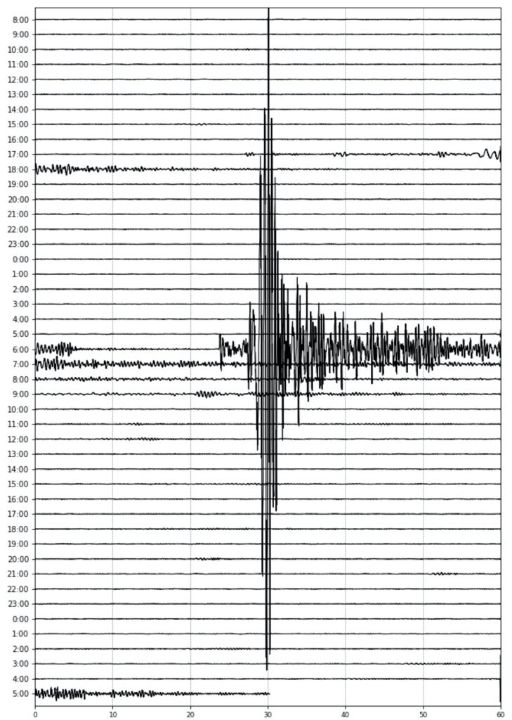
The outlined seismic data indicates activity over the dike from April 1, 6:30 AM to 12:00 PM. The visual breakdown includes earthquake magnitudes, hourly counts of seismic events, latitudes, and longitudes.
Likelihood of New Eruptive Opening Decreasing
Looking at the southern segment of the dike — where eruptive activity has stopped and seismicity has calmed — the chances of the recent eruption restarting grow smaller with time. In the northeastern section, the probability of new eruptive openings is also dropping, though persistent microseismicity means it cannot be ruled out entirely.
Future deformation measurements will shed light on whether magma is still moving from Svartsengi into the dike and how underground accumulation is evolving. The latest hazard assessment remains in effect until April 4 at 3:00 PM, unless something changes significantly. Key updates include:
- Zone 3 (Sundhnúkur crater row) has been revised down from very high (purple) to high (red).
- Zone 4 (Grindavík): Hazard status has shifted to considerable (orange) from high (red) owing to decreased likelihood of an eruptive opening.
- Zone 6’s classification has moved to considerable (orange) from high (red).
Geological assessments and monitoring of faults within Grindavík fall outside the remit of the Icelandic Meteorological Office. GPS data hint at fault movement in Grindavík closely tied to the dike intrusion of April 1.
The hazard map issued by the Icelandic Meteorological Office does not account for personal risks associated with entering marked zones. People are directed to follow risk assessments prepared by the Government Task Force on Grindavík and the recommendations of the Suðurnes Police Commissioner.
Updated April 1 at 21:40 UTC
Webcam observations show no eruptive activity at the fissure that opened earlier today just north of Grindavík. Only scattered glows remain visible along the fissure and within the lava field.
Seismic activity and deformation linked to magma movements continue at the northeastern end of the dike. Activity has been recorded across a roughly 20 km length, from the south end of the fissure to the area of most intense seismicity.
These earthquakes are occurring at considerable depth, with nothing to suggest the moving magma is approaching the surface. Current modelling puts the volume of magma that has flowed from Svartsengi into the dike beneath the Sundhnúkur crater row at approximately 15 million cubic meters, with only a fraction reaching the surface. Before the eruption, roughly 22 million cubic meters had accumulated in the reservoir beneath Svartsengi, leaving room for further movement.
As long as seismic activity and deformation continue within the dike, the possibility of a new eruptive fissure has to be kept in mind — particularly where seismic events are currently most concentrated. If eruptions were to occur, they could be accompanied by strong seismic activity potentially felt by residents in Vogar.
The accompanying map illustrates reviewed earthquakes on the Reykjanes Peninsula since 6 AM on April 1.
Updated April 1 at 18:30 PM
Volcanic activity north of Grindavík is subsiding, with little visible in webcams or recent drone footage. Seismic activity does persist, however. Near the southern section of the magma dike things have quietened, while the northern end remains active and has been escalating northward over the past few hours. The seismic events now reach nearly 9 km north of the northernmost eruption fissure formed during the August 2024 eruption, with the largest tremors around magnitude 3 — felt in Vogar, about 7 km northwest of the active area.
The map presents the positions of earthquakes recorded on April 1, 2025, alongside known fault lines in the vicinity. The dominant fracture configuration is NE-SW, with no mapped fractures in the Vogar region.
Deformation data suggest that magma flow from Svartsengi into the dike beneath the Sundhnúkur crater row is ongoing, with seismic activity pointing to continued northeastern movement. Earthquakes are occurring at depths of around 4-6 km, and analysis of deformation data is still underway. As long as significant seismic activity and deformation continue, the chance of magma reaching the surface — whether along the Sundhnúkur crater row or in nearby areas of concentrated activity — stays real.
The following map illustrates the lava extent as of 12:34 PM, generated by the eruption that began earlier today. The map is based on ICEYE satellite imagery.
The hazard assessment has been revised and remains in effect until 3 PM on April 2, unless circumstances change. The hazard level for Zone 3 (Sundhnúkur crater row) remains very high (purple). In Zone 4 (Grindavík), the hazard designation has dropped to high (red) due to reduced risks from ashfall and gas pollution. Zones 5 and 7 have both moved up from moderate (yellow) to considerable (orange) due to persistent seismic activity near the dike’s northeastern end.
Updated April 1 at 14:40 PM
Webcam observations show that volcanic activity has dropped sharply over the past hour.
Seismic activity continues, centred mainly on the northern and southern sections of the dike intrusion.
Deformation measurements consistently point to ongoing northeastern movement, confirming that magma is still flowing into the dyke.
Updated April 1 at 12:35 PM
The eruptive fissure has extended to roughly 1,200 meters and is continuing to push southward.
The Icelandic Meteorological Office confirmed a broken hot water pipeline in northern Grindavík, adding further evidence of significant fault movements within the town.
Seismic activity is being logged continuously across the entire dike intrusion, with the most intense movements at the northeastern end. The intrusion now extends over 3 km further northeast than anything seen in previous eruptions. Data also show ongoing displacement toward the northeast, confirming that magma is still moving through the dike.
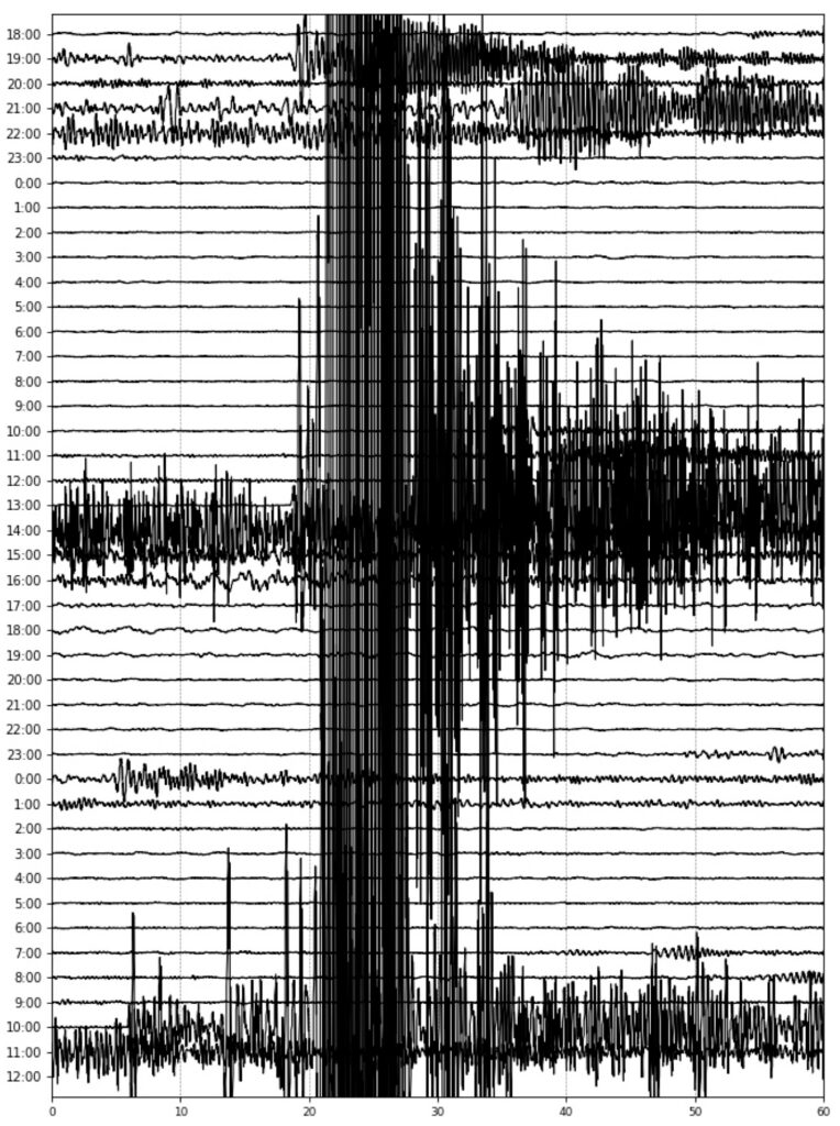
Seismic data over the dike intrusion since 4 AM this morning, April 1.
Updated April 1 at 11:00 AM
The fissure is still extending southward, and a new eruptive fissure has opened a few hundred meters inside the protective barriers north of Grindavík — sitting between the barriers and the town itself.
(The new fissure opening is on the left in the photo).
Today’s forecast calls for southwesterly winds carrying volcanic gas northeastward, including toward the capital region. Winds are expected to ease this evening, concentrating gas pollution around the eruptive fissure. Tomorrow morning winds will shift to northwesterly and then westerly, pushing gas southeastward and eventually eastward — which could affect Þorlákshöfn and Ölfus. The gas dispersion forecast is available here.
Seismic activity is persisting at the southern end of the magma intrusion and also north of Stóra-Skógfell. Earthquakes near Reykjanestá are likely triggered by stress releases associated with the seismicity in the Sundhnúkur crater row. Further updates can be found here.
Updated April 1 at 10:30 AM
Initial reports from the Coast Guard surveillance flight put the fissure at roughly 700 meters in length. The situation looks relatively stable for now, though further expansion to the north or south remains possible. Seismic and deformation monitoring is ongoing.
The hazard assessment has been updated. The alert level for the Sundhnúkur crater row (Zone 3) is now very high (purple), while the hazard level for Grindavík (Zone 4) has risen from high (red) to very high (purple). This assessment stands until April 2 at 10:30 AM unless conditions change.
Updated April 1 at 10:00 AM
The fissure has grown to roughly 500 meters and has breached the protective barrier north of Grindavík. It is still expanding, and further growth southward is possible.
Updates from the Coast Guard helicopter are forthcoming.
The map depicts the fissure which has now reached about 500 m in length.
Updated April 1 at 9:45 AM
An eruption has begun just north of the protective barriers adjacent to Grindavík.
A Coast Guard helicopter will depart shortly to confirm the exact location and scale of the eruption.
The magma intrusion beneath the Sundhnúkur crater row has now reached approximately 11 km — the longest recorded length since November 11, 2023.
Further details are forthcoming.
Given the current wind direction, gas pollution from the eruption will drift northeast and could affect the capital area. How intense that pollution will be remains uncertain.
Access the Icelandic Met Office’s gas dispersion forecast here.
Updated April 1 at 9:20 AM
GPS signals are showing stronger activity than anything seen in earlier events on the Sundhnúkur crater row, indicating substantial magma movement.
The data show magma advancing both northeast and south toward Grindavík. Where exactly it will surface is still unknown at this point, though it is worth noting that the southward shift in deformation signals was not observed during the November 2024 eruption.
Emergency responders in Grindavík report that tremors are being felt in the town, and visible signs of deformation suggest possible fault movements beneath the surface.
Updated April 1 at 7:25 AM
An earthquake swarm began around 6:30 AM this morning on the Sundhnúkur Crater Row, between Sýlingarfell and Stóra-Skógfell — a pattern that mirrors what was seen before previous eruptions.
This was followed by a clear shift in deformation data and pressure changes in boreholes managed by HS Orka. Both signals indicate the start of a magma intrusion.
No magma has reached the surface yet, but an eruption looks increasingly likely.
Updates will continue.


